
US Army Reserve Army Mapper and PRISMS Data Collection and Development


Pond & Company is currently supporting the Army Reserve’s initiative to inventory, collect and develop GIS and Building Space data with facility and space utilization surveys for optimal planning and management. This effort includes developing or standardizing Common Installation Picture (CIP) GIS layers and Proactive Real-property Interactive Space Management System (PRISMS) data development to support the USAR 81st, 63rd, 88th, 99th RSCs and 9th MSC.
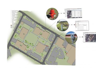
This project ultimately delivers the first complete USAR GIS dataset for facilities management within the SDSFIE standard and ESRI geodatabase format for Army Mapper, consisting of over 1,000 locations across the continental United States, Puerto Rico, Alaska, Hawaii, American Samoa, Guam and Saipan. The project includes 685 field site visit locations for GIS/GPS data and floor plan verification with an 18 month period of performance. The scope entails the following tasks:
- Data Collection and Development
Army Mapper
- Develop SDSFIE-compliant GIS layers including Virtual Base, Property Boundary, AT/FP Setback, Fences, Gates, Parking, Sidewalks, Roads, Airfields, Power Poles, Manhole Covers, Pad & Pole Mount Transformers, Lift Stations, Communication Boxes/Vaults, Meter Points, Hand Holes, Maintenance Holes, Hydrants, and the last highway mile marker post off the property.
- Metadata Development – Develop/Update metadata files for all current geospatial data layers and create metadata for all newly created layers in accordance with the FGDC and IGI&S guidelines.
- Onsite Data Collection – Geospatial data acquisition with sub-foot GPS technology, and refinement of aerial orthophotography mapping for reconciliation of GPS data gathered in field.
- Data Integration – Cross-reference existing data against data collected in the field and report discrepancies.
PRISMS:
- Develop CADD floor plan data and Facility Space Utilization per Facility Category Code in PRISMS with the intent of verifying real property data in HQIIS and to support space utilization planning and facility management.
- Develop real property reconciliation reports based on verified plans. Data to be used for update of DoD real property databases and Facility TABs.
- Produce real estate assessment/utilization reports;
- Reporting – Provide progress reports through web-based application
- Upload data to Army Mapper and PRISMS Enterprise Systems.
Related Projects

Related News

Sam Briuglio promoted to Senior Vice President of Pond’s Federal Program
NEW ORLEANS, Louisiana – (9.24.18) – Pond, an industry leader in planning, architecture, engineering and construction services, is pleased to announce the promotion of Sam Briuglio to Senior Vice President of the Federal Program, including Federal Master Planning and...

Pond honored for notable contributions to SAME
Pond was honored to be selected as the Seymour S. Greenfield Sustaining Member Award winner for 2017. Senior Project Manager Pam Little joined Executive Vice President John Cassidy, Vice President Mike Magahey, Program Manager George Fragulis, Program Manager Steve...

Pond wins big at the 2018 FPD Workshop
Pond had tremendous showing at the 2018 Federal Planning Division (FPD) of the American Planning Association (APA) Workshop in New Orleans. Our Federal Planning and Geospatial Program was not only a sponsor and vendor of the event, but also co-hosted a widely attended...